The Leeds Heat Planning Tool is a free and practical tool for use by local authorities and other city stakeholders in England and Wales. It helps to link commercial opportunities with nearby opportunities for meeting wider social objectives of the town or city, such as alleviating fuel poverty.
Background
The tool was developed based upon research undertaken through interviews with a range of district heating developers including local authority officers, energy companies and a housing association. The research aimed to investigate
- What are the motivating objectives for local authorities working on district heating?
- How are fuel poverty and other social considerations factored into the district heating planning process?
- What decision-support tools are used by local authorities in the pre-feasibility stage?
- Do these tools support developments that meet the main motivating objectives of local authorities?
A full write up of this research can be downloaded here.
Intended use
The Leeds Heat Planning Tool is intended to offer an evidence base to convince decision makers that district heating is worth investing time or capital in. In the context of limited resource and budgets, the ability for energy planners to align their business case with the strategic priorities of a local authority is critical to allow investment of valuable staff time and capital over other priorities.
How the tool works
The tool combines appropriate assessment criteria with spatial mapping of freely available socio-economic, geographic, technical and housing stock data.
It uses publically available data at a resolution of census output area (approximately 150 households per area). Users can also add in their own data for extra detail.
For a chosen town or city, each output area is scored based on whether it exhibits characteristics to suggest there are technical, economic and social benefits of DH to be realised in that area.
It looks at information such as housing density, proximity to large heat demands such as swimming pools or hospitals and proximity to existing heat sources. Alongside this information, data reflecting indicators of fuel poverty and multiple deprivation are included to allow social considerations to be incorporated into the decision-making process.
Data categories
It uses data from the Census 2011 and the Department for Energy and Climate Change, alongside user-added data,
| Techno-Economic |
Governance |
Social |
Demand density
Existing heat sources |
Ownership of households
e.g. Social housing,
Privately rented,
Owner occupied. |
Existing heating type
Fuel poverty
Index of multiple deprivation
Eligibility for ECO |
Calculating a score for each area
Each area is given a score based upon whether it meets certain criteria. If an area is in the top selected percentile for a given characteristic then its score is increased.
When multiple characteristics are considered they are weighted to represent their importance for the decision maker.
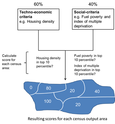
Fig. Example of how scoring is calculated to assess census output areas for district heating suitability.
|